Suffolk Biodiversity Validation Checklist
The Suffolk Biodiversity Validation Checklist helps applicants and local planning authorities ensure that planning applications include the ecological information needed for proper determination. It was developed by the Suffolk Biodiversity Partnership Planning Support Group and is adopted by all Suffolk planning authorities.
The checklist should be used where a Biodiversity or Geodiversity Assessment is required because the site includes or is close to:
- Sites designated or proposed for their biodiversity or geodiversity importance, including Sites of Special Scientific Interest (SSSIs), Ramsar sites, National Nature Reserves (NNRs), Special Areas of Conservation (SACs), Special Protection Areas (SPAs), County Wildlife Sites (CWSs), County GeoSites (CGSs), and UK and Suffolk Priority Habitats
- Areas including or close to recorded locations of protected species and UK and Suffolk Priority Species
- Other areas identified in pre-application discussions as potentially containing protected or priority species
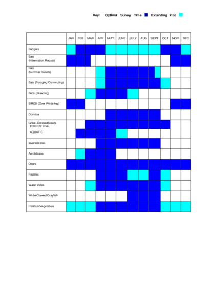
The checklist includes the relevant extract from BS42020, the British Standard Code of Practice for Biodiversity in Planning and Development, which sets out the requirement to provide adequate ecological information to enable determination of planning applications. The appropriate seasons for undertaking ecological surveys are identified in Figure 2, attached to Table 1 of the document.
The checklist should now be read alongside the requirements of mandatory Biodiversity Net Gain (BNG), which applies to most planning applications in England from February 2024. Applicants will need to demonstrate 10% BNG in addition to meeting the survey requirements set out in the checklist.
Suffolk Biodiversity Validation Checklist – 2019
Last updated September 2019. This document predates mandatory Biodiversity Net Gain requirements. It remains current guidance for ecological survey validation but should be read in conjunction with current BNG legislation and guidance.
A Biodiversity or Geodiversity Assessment is required where the site includes or is close to:
- Sites designated or proposed for their biodiversity or geodiversity importance, including Sites of Special Scientific Interest (SSSIs), National Nature Reserves (NNRs), Special Areas of Conservation (SACs), Special Protection Areas (SPAs), Ramsar sites, County Wildlife Sites (CWSs), County GeoSites (CGSs), and UK and Suffolk Priority Habitats (see Tables 2 and 3)
- Areas including or close to recorded locations of protected species and UK and Suffolk Priority Species (see Table 1)
- Other areas identified in pre-application discussions as potentially containing protected or priority species
Where an assessment is required according to the development type and species affected, as identified in Tables 2 and 3, the appropriate seasons for undertaking ecological surveys are identified in Figure 2 attached to Table 1.
Where there are likely to be biodiversity impacts associated with a proposed development, Suffolk planning authorities will determine the planning application in accordance with Clauses 7, 8 and 9 of BS42020 Biodiversity – Code of Practice for Planning and Development (2013). This provides applicants with a transparent process that is in accordance with a nationally recognised professional standard.
In addition to these biodiversity validation requirements, other information may be requested by the LPA as part of the determination of an application. This can include information to inform Habitats Regulations Assessments (HRA), provided by the applicant to enable the LPA to prepare an HRA screening report.
TABLE 1
Local Requirement for Protected Species, UK Species of Principal Importance (Priority Species): Criteria and Indicative Thresholds (Trigger List) for when a Survey and Assessment is Required with an Application to meet BS42020:2013
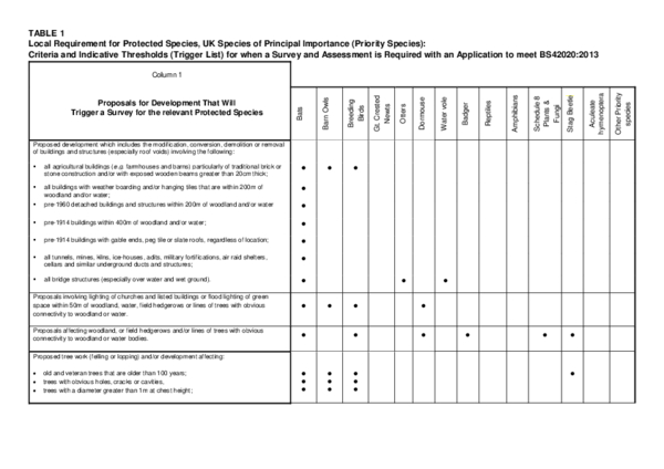
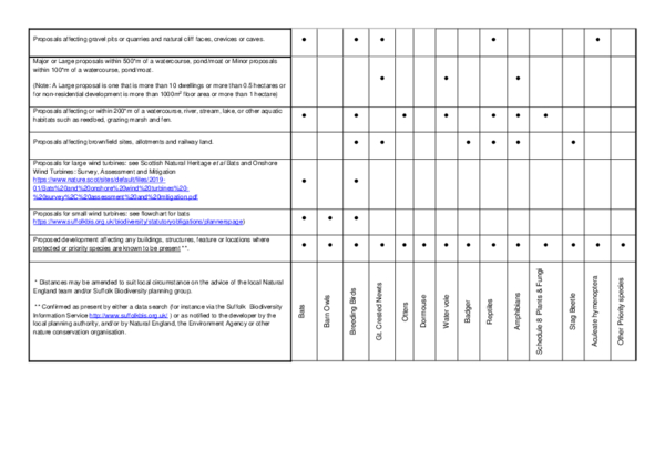
Exceptions for When a Full Species Survey and Assessment may not be Required
- Following consultation by the applicant at the pre-application stage, the LPA has stated in writing that no protected or priority species surveys and assessments are required.
- If it is clear that no protected or priority species are present, despite the guidance in the above table indicating that they are likely, the applicant should provide evidence with the planning application to demonstrate that such species are absent (for example, a brief report from a suitably qualified and experienced person, or a relevant local nature conservation organisation).
- If it is clear that the development proposal will not affect any protected or priority species present, then only limited information needs to be submitted. This information should (i) demonstrate that there will be no significant impact on any protected or priority species present and (ii) include a statement acknowledging that the applicant is aware that it is a criminal offence to disturb or harm protected species should they subsequently be found or disturbed.
In some situations, it may be appropriate for an applicant to provide a protected or priority species survey and report for only one or a few of the species shown in the table above – for example, those that are likely to be affected by a particular activity. Applicants should make clear which species are included in the report and which are not because exceptions apply.
TABLE 2
Local Requirements for Designated Sites and Priority Habitats and Habitats Listed for Suffolk: Criteria (Trigger List) for When a Survey and Assessment are Required with an Application
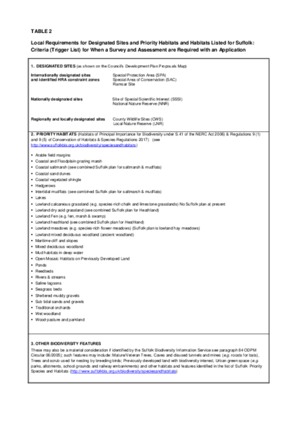
Exceptions when a full survey and assessment may not be required
International and national sites: A survey and assessment will not be required where the applicant is able to provide copies of pre-application correspondence with Natural England, where the latter confirms in writing that they are satisfied that the proposed development will not affect any statutory sites designated for their national or international importance.
Regional and local sites and priority habitats: A survey and assessment will not be required where the applicant is able to provide copies of pre-application correspondence with the Local Planning Authority's ecologist (where employed), or ecological advisor and/or Suffolk Wildlife Trust, confirming they are satisfied that the proposed development will not affect any regional or local sites designated for their local nature conservation importance or any other priority habitats or listed features.
TABLE 3
Local Requirements for Designated Geodiversity Sites and Features: Criteria (Trigger List) for when a Survey and Assessment are Required
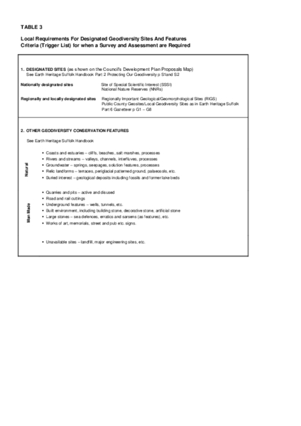
Exceptions when a full survey and assessment may not be required
International and national sites: A survey and report will not be required where the applicant is able to provide copies of pre-application correspondence with Natural England, where the latter confirms in writing that they are satisfied that the proposed development will not affect any statutory sites designated for their national importance.
Regional and local sites: A survey and report will not be required where the applicant is able to provide copies of pre-application correspondence with appropriate local geological specialists (such as GeoSuffolk) confirming they are satisfied that the proposed development will not affect any regional or local sites designated for their geodiversity conservation importance.
Appendix B – Ecological Survey Seasons
The survey calendar below broadly indicates appropriate survey periods. For further details, refer to the published guidance and mitigation guidance documents listed in the reference section below.
Points to note regarding surveys:
- It is important that surveys for protected (and priority) species are carried out at an appropriate time of year, as indicated by published guidance and/or nationally recognised survey guidelines and methods where available. This is so that there is the greatest chance of detecting protected (and priority) species if present. At other times of year it can be very difficult to detect protected species as their levels of activity decrease as temperatures decline, they take refuge in areas that are difficult to access, and bad weather destroys evidence of their presence. Surveys undertaken at an inappropriate time of year will not provide a true reflection of the likely impacts of a proposed development on protected species.
- For certain species and habitats, surveys can be carried out at any time of year, but for other species particular times of year are required to give the most reliable results, as indicated above.
- Surveys conducted outside of optimal times will be unreliable and may result in insufficient information for determination of an application. For certain species (e.g. Great Crested Newt) surveys over the winter period are unlikely to yield any useful information. Similarly, negative results gained outside the optimal period should not be interpreted as absence of a species, and further survey work may be required during the optimal survey season. This is especially important where existing surveys and records show the species has been found previously on site or in the surrounding area.
- Species surveys are also very weather dependent, so it may be necessary to delay a survey or to carry out more than one survey if the weather is not suitable – for example, heavy rain is not good for surveying for otters as it washes away their spraint (droppings), and bat surveys carried out in wet or cold weather may not yield accurate results.
- Absence of evidence of a species does not necessarily mean that the species is not there, nor that its habitat is not protected (e.g. a bat roost is protected whether any bats are present or not).
- SBIS holds useful existing species information and records and can be consulted at the data request stage.
Published Survey and Mitigation Guidance
Competent ecologists should carry out any surveys and assessments. Where surveys involve disturbance, capture, or handling of a protected species, only a person licensed by Natural England can undertake such surveys. Surveys should follow published national or local methodologies. The following guidance documents provide information on survey methodologies, assessment of impacts, and mitigation measures.
General
- CIEEM Guidelines for Ecological Report Writing, 2nd edition (December 2017)
- Natural England: protected species publications
Bats
- Bat Conservation Trust (2016). Bat Surveys: Good Practice Guidelines. London: Bat Conservation Trust. Free download on BCT website
- Mitchell-Jones, A.J. (2004). Bat Mitigation Guidelines. Peterborough: English Nature.
- Mitchell-Jones, A.J. & McLeish, A.P. (2004). Bat Workers' Manual. Peterborough: JNCC.
- Schofield, H.W. (2008). The Lesser Horseshoe Bat Conservation Handbook. Ledbury: The Vincent Wildlife Trust.
Great Crested Newts
- English Nature (2001). Great Crested Newt Mitigation Guidelines. Peterborough: English Nature.
- Langton, T., Beckett, C. & Foster, J. (2001). Great Crested Newt Conservation Handbook. Halesworth: Froglife.
Dormice
- Bright, P., Morris, P. & Mitchell-Jones, A.J. (2006). The Dormouse Conservation Handbook, 2nd edition. Peterborough: English Nature.
Otters
- Chanin, P. (2003). Ecology of the European Otter. Conserving Natura 2000 Rivers Ecology Series No. 10. English Nature, Peterborough.
Water Voles
- Strachan, R. & Moorhouse, T. (2006). Water Vole Conservation Handbook, 2nd edition. Oxon: The Wildlife Conservation Research Unit.
Badgers
- RSPCA (1994). Problems with Badgers? Horsham, Sussex: RSPCA.
Barn Owls
- Barn Owl Trust (2002). Barn Owls on Site: A Guide for Developers and Planners. Peterborough: English Nature.
- Royal Society for the Protection of Birds (2007). Wild Birds and the Law England and Wales: A Plain Guide to Bird Protection Today. Sandy, Bedfordshire: RSPB.
White-clawed Crayfish
- Peay, S. (2000). Guidance on Works Affecting White-clawed Crayfish. Peterborough: English Nature & Leeds: Environment Agency.
- Holdich, D. (2003). Ecology of the White-clawed Crayfish. Conserving Natura 2000 Rivers Ecology Series No. 1. Peterborough: English Nature.
Reptiles
- English Nature (2004). Reptiles: Guidelines for Developers. Peterborough: English Nature.
- Gent, T. & Gibson, S. (1998). Herpetofauna Worker's Manual. Peterborough: JNCC.
Phase 1 Survey
- Nature Conservancy Council (1990). Handbook for Phase 1 Habitat Survey. Peterborough: JNCC.
Recommended Survey and Assessment Template for Protected Species
As a guide to what constitutes sufficient information for the planning authority, any submitted survey and report should be based on the following:
- Executive summary (no more than one side of A4)
- Introduction
- Background to development – justification for why the proposal is necessary
- Description of the proposed works (e.g. building conversion, new build, demolition)
- Summary of statutory provisions for protected species
- Survey and site assessment
- Qualifications and experience of surveyor(s), e.g. details of EPS licence number and equipment used (type of bat detectors and data loggers)
- Scale plan/map and 6 or 8 figure grid reference
- Desktop data trawl – details of information sought and obtained from local records centre
- Conclusions of walkover survey
- Objectives of the detailed survey
- Field surveys – details of internal/external inspections, emergence/re-entry surveys, transect surveys, timings (day/evening), dates, weather conditions (wind, rain, temperature tabulated for multiple survey visits)
- Survey results – including text, tables, photos, maps, illustrations, plans (with raw data appended including sonagrams)
- Site/habitat – description of features of value to commuting, foraging, and roosting bats
- Interpretation and evaluation of results – estimate of bat numbers and status of site (e.g. presence of hibernation, maternity or feeding roosts, swarming sites) and their significance locally and regionally
- Impact assessment
- Short-term disturbance impacts
- Long-term impacts
- Roost modification
- Roost loss
- Fragmentation and isolation of habitat
- Post-development interference impacts (e.g. lighting, use of loft space)
- Predicted scale of impacts
- Land ownership and viability for any proposed mitigation sites
A submitted report must first demonstrate that alternatives have been considered and show why avoidance of negative impacts is not feasible, before providing a strategy that details mitigation and compensation proposals.
- Measures for mitigation, compensation, and enhancement
- Full mitigation, compensation, and enhancement plan/strategy
- Works to be undertaken by an ecologist or suitably qualified person
- Capture and exclusion (as an example of possible works)
- Works to be undertaken by the developer/landowner
- In-situ retention of bat roost
- Modification of existing roosts
- New roost creation
- Scaled maps/plans
- Compliance with development plan policies and statutory obligations
- How biodiversity features will change with development – a prediction of net loss or gain
- How the proposal is in accordance with the relevant policies within the development plan
- Likelihood of obtaining any necessary Regulation 44 European Protected Species licences
- Post-development site safeguard
- Habitat/site management and maintenance where necessary
- Population monitoring, roost usage, etc.
- Mechanism for ensuring delivery – planning conditions/obligations and/or Regulation 44 licence
- Timetable of works
Evidence that conservation proposals are compatible with the proposed development timetable
| Development management |
|---|
| Data for Ecological Consultants |
| Biodiversity Net Gain |
| Suffolk Biodiversity Validation Checklist |